6
$\begingroup$

I have a set of data on all the stars (well, to a magnitude of 9 or so) with the values of the following properties:

  • magnitude,
  • right ascension and,
  • declination.

Now I'd like to create a planar (rectangle in shape) map of the entire sky (both hemispheres), without stretching anything (keeping all constellations etc., as seen in the sky.)

I know this is more of a math question, but I guess there's some fairly known function (or ratio? I haven't found it on Google, though) to achieve this; if so, how?

$\endgroup$
0

4 Answers 4

13
$\begingroup$

I'd like to create a planar (rectangle shaped) map of the entire (both hemispheres) sky, with stretching anything (keeping all constellations etc. as seen in the sky).

This is a physical impossibility. You simply cannot map a spherical entity (the celestial sphere) onto a plane without introducing some distortion. Cartographers have developed many different projections in their efforts to solve this problem, but none is perfect. All of them are forced to introduce distortion at some point.

The Mercator projection suggested in another answer is notoriously inaccurate as you get closer to the poles, making Greenland as large as South America, and stretching Antarctica into an impossible shape.

The best solution is to forget about mapping the whole sky, but to concentrate on smaller areas where the distortions are not as severe. This is what most star atlases and planetarium software programs do.

$\endgroup$
3
  • 2
    $\begingroup$ Not just physical but mathematical impossibility! $\endgroup$
    – Andrew
    Commented Sep 12, 2011 at 10:00
  • $\begingroup$ Thank you for your answer, I should have asked for the one with the least distortion. However, the hint about the smaller areas is the one approach I gonna try. $\endgroup$
    – Dänu
    Commented Sep 13, 2011 at 14:03
  • $\begingroup$ Great answer! I want to develop the same but in a sphere. How can I do it? $\endgroup$
    – VansFannel
    Commented Jul 16, 2015 at 17:10
5
$\begingroup$

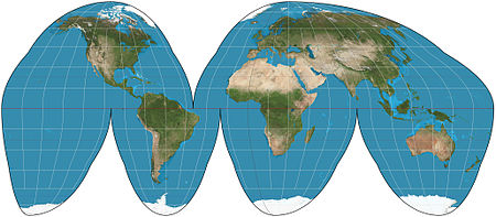
As Geoff said, what you ask for is a mathematical impossibility. That being said, however, there are LOTS of ways to draw a map, and some come closer to what you are looking for than others. This article provides lots of general background on map projections. You will want to pay particular attention to the section that discusses classifications.

enter image description here

It sounds like you would be most interested in the Interrupted Goode homolosine projection, applied to the sky. Obviously, you wouldn't want the same interruptions for the Earth and the sky, but that's probably your best bet.

$\endgroup$
0
3
$\begingroup$

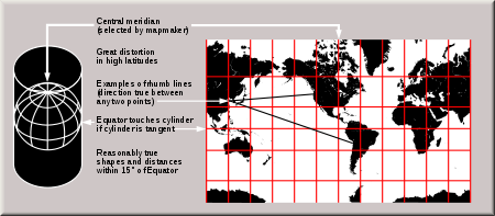
what you're looking for is a Mercator projection is a cylindrical map projection type of flat land to develop but can be applied to the stars.

Mercator, by projection, intended to represent the Earth's spherical surface on a cylindrical surface tangent to Ecuador, which generates a map to deploy terrestrial plane.

It is an idealized model that treats the earth as an inflatable balloon that is inserted into a cylinder and begins to "inflate" the cylinder volume occupied by printing a map on its outer face.

This cylinder cut lengthwise and deployed would be the representation you need.

this are the ecuations that you need to do representation:

if $ \phi $ is $AR$ and $\lambda$ is $DEC$, then:

$$ x = \lambda -\lambda_0$$ (being the length $λ_0$ center of the map)

$$y = ln [tag (\frac{\pi}{4}-\frac{\phi}{2})] $$

enter image description here

$\endgroup$
1
  • 1
    $\begingroup$ This is only one projection of many, and is likely to be very poor for the question asker's purpose. $\endgroup$
    – Andrew
    Commented Sep 12, 2011 at 10:00
2
$\begingroup$

I presume you weren't going to do this by hand, and I'm not sure what method you intended to use to calculate the coordinates, but I think that the following site may be useful:

Matthew's Map Projection Software

It's a collection of C++ programs that generate maps from raw RA/Dec data. It supports about 15 different projections.

$\endgroup$
1
  • $\begingroup$ proj4 also does this $\endgroup$
    – user854
    Commented Aug 17, 2015 at 22:56