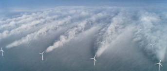
At Horns Rev windfarm off the coast of Denmark, sometimes in winter, clouds appears in the wake of the turbines. I've only seen photos of the phenomenon when the wind direction is exactly aligned with the grid layout - that is, it's blowing directly from a turbine to its closest neighbour. That may be because it's most picturesque then (and thus most likely to be photographed); or it may be that there's something going in the fluid dynamics that requires that alignment for the phenomenon to occur.

I guess there are several things at work here: that wake losses are highest when wind is exactly aligned with one axis of the turbine grid; that air temperatures vary with height above water; that the temperature is low enough to be close enough to form fog anyway (and in the photo, it looks like they're a layer of mist just above the sea's surface); that the turbine's wake is mixing air from different altitudes
A study started in early 2011 at Lawrence Livermore National Laboratory on turbine wakes, following on from a study by DONG energy on wakes at Horns Rev (787 kB pdf here)
I'm wondering if it's possible to predict when the phenomenon in the photo here might occur. So my question is - what's the specific formulation of what's going on, here: what does the quantification of causes and effect look like?
